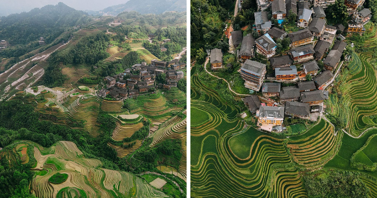
China is so geographically restless that describing it as “scenic” feels almost unfairly modest. One moment, the land resembles a watercolor, with green rice terraces folding down a mountain in luminous steps. A few hundred miles away, it becomes a minimalist composition made of sand, salt, stone, and one stubborn road. Then come glacial lakes, grasslands, river deltas, forests, villages, and cities that appear to have been arranged by an exceptionally ambitious geometry teacher.
That remarkable variety is the heart of this 49-image aerial photography collection. Inspired by photographer Florian Delalée’s The Beauty of China From the Air project, the series grew from extensive travel through regions including Sichuan, Inner Mongolia, Xinjiang, and Tibet. Seen from above, familiar categories such as mountain, desert, farm, and village stop behaving like simple labels. They become patterns, textures, and stories written across the ground.
China Is Not One Landscape but a Continental Collection
China stretches roughly 3,100 miles from east to west and about 3,400 miles from north to south. Within that enormous frame are high plateaus, towering mountain systems, sandy deserts, dense forests, fertile plains, subtropical hills, river basins, and long coastal zones. Western China is generally higher, drier, and more mountainous, while many of the country’s most productive agricultural areas and densely populated settlements lie farther east.
This transition is especially dramatic from the air. In the west, the landscape often appears monumental and sparse, dominated by bare rock, snow, dry basins, and distances that are difficult to judge. Moving eastward, rivers branch, fields multiply, roads tighten into networks, and settlements become more frequent. The ground gradually changes from a geological epic into an extraordinarily detailed circuit boardexcept this circuit board grows rice, wheat, tea, fruit, and entire towns.
Aerial photography makes these contrasts easier to understand because it removes the conventional horizon. Without a foreground and background telling the eye where to begin, viewers look directly at structure: the curve of a river, the contour of a terrace, the border between a desert and an oasis, or the point where a village gives way to farmland.
Why Aerial Photography Changes the Story
Ground-level landscape photography often emphasizes grandeur. A mountain towers over the viewer. A canyon opens ahead. A forest surrounds the camera. Aerial photography does something different: it reveals relationships. It shows how water organizes farmland, how roads negotiate steep slopes, how communities gather around usable land, and how human designs frequently echo natural forms.
From above, braided rivers resemble silver roots. Dunes become waves frozen in mid-swell. Rice terraces look like fingerprints. Rows of trees form green stitching across brown earth. Even a highwayusually nobody’s idea of a romantic subjectcan become an elegant line threading through difficult terrain.
The viewpoint also creates visual surprises. The brain may first interpret a picture as an abstract painting before recognizing the actual subject. “Is that marble?” becomes “No, it is a salt lake.” “Is that folded fabric?” becomes “Those are cultivated fields.” That delayed recognition encourages viewers to stop, look again, and discover details they might otherwise miss.
Several Geographic Worlds Across 49 Pictures
The Tibetan Plateau: Scale Without an Obvious Ending
The Tibetan Plateau is frequently called the “roof of the world,” and aerial imagery explains why the phrase has endured. Its high terrain includes broad plains, mountain chains, glaciers, wetlands, and intensely colored lakes. Shadows stretch across enormous slopes, while distant peaks merge into layers of blue, gray, and white.
Scientific observations add another dimension to those beautiful views. Satellite records have documented significant changes in many plateau lakes, with some becoming larger or more numerous as rising temperatures affect glaciers, snow cover, precipitation, evaporation, and runoff. A brilliant blue lake is therefore more than a decorative splash of color. It is part of a high-altitude water system that continues to change.
Xinjiang and the Taklimakan: The Art of Emptiness
In Xinjiang, the Taklimakan Desert occupies a vast depression surrounded by rugged mountain systems. Its immense dune fields include formations that can rise hundreds of feet. From above, this apparently empty environment becomes surprisingly intricate. Wind draws crescents, ripples, ridges, and overlapping curves into the sand, then revises the composition whenever it pleases.
The strongest desert photographs usually contain an element that provides scale: a road, vehicle, dry riverbed, line of vegetation, or patch of cultivated ground. Without that reference, a dune might be ten feet tall or ten stories tall. With it, the image becomes a lesson in proportionand a reminder that the desert is not an oversized sandbox, despite what the texture suggests.
Inner Mongolia: Grasslands, Dunes, and Seasonal Color
Inner Mongolia complicates the easy assumption that northern China is simply dry and brown. Its terrain includes grasslands, desert environments, agricultural zones, wetlands, and forested areas. Seasonal changes can shift the aerial palette from spring green to summer gold and eventually to winter white.
Details that seem insignificant at ground level become visible patterns from above. Livestock paths create faint networks across grassland. Rivers bend through open meadows. Windbreaks and planted tree rows introduce straight lines against softer natural contours. This tension between geometry and wildness is one of the recurring pleasures of viewing the Chinese landscape from above.
South China Karst: Mountains That Look Invented
Southern China’s karst landscapes are among the country’s most recognizable geographic forms. Limestone shaped by water has produced steep towers, caves, sinkholes, enclosed valleys, and unusual ridgelines across areas of Guangxi, Guizhou, Yunnan, and Chongqing.
From the air, the terrain becomes even stranger. Conical hills repeat into the distance while villages and farms occupy the flatter spaces between them. Rivers curve around the limestone instead of attempting to argue with it. The result looks carefully designed, although the principal designers were water, rock, gravity, and an unreasonable amount of time.
Rivers and Deltas: The Landscape’s Circulatory System
Many of China’s principal rivers flow from the higher western regions toward the eastern seas. The Yangtze travels approximately 3,915 miles from its headwaters to the East China Sea, crossing several climatic and geographic zones. The Yellow River, historically central to Chinese civilization, transports sediment that has helped shape vast plains and delta environments.
Aerial pictures reveal that rivers are not the tidy blue lines shown on basic maps. They divide, reconnect, erode banks, build sandbars, flood wetlands, irrigate fields, and carry sediment toward the coast. A river delta can resemble a leaf, with channels branching like veins. It is beautiful, but it is also busy moving water, soil, nutrients, wildlife, people, and economic activity.
Terraced Fields: Agriculture as Sculpture
Terraced fields are among the clearest examples of people adapting to steep terrain. Rather than flattening an entire mountainan inconvenient plan unless one owns several million shovelsfarmers reshape its surface into narrow, cultivable steps.
From above, those steps follow the mountain’s contours, producing rings, waves, ribbons, and nested curves. Water-filled rice terraces mirror the sky during planting season. Later, the same fields may become vivid green and then golden before harvest. One location can therefore produce several completely different aerial compositions during a single year.
These are not merely attractive patterns. Terraces represent generations of knowledge concerning soil, water, crop cycles, slope stability, and labor. Their beauty comes partly from the fact that every graceful curve also serves a practical purpose.
What the Colors in Aerial Pictures Can Reveal
Aerial colors are visually seductive, but they are not random decoration. Turquoise water may contain fine mineral particles associated with glaciers. Rust-colored slopes can indicate iron-rich rock or soil. Pale desert basins may contain salt, clay, or dry lake deposits. Dark forest patches can reveal changes in moisture or elevation, while the colors of agricultural areas may reflect crop type, irrigation, season, or recent rainfall.
The Qaidam Basin, for example, has been recorded in Landsat imagery showing a remarkable combination of mountains, desert surfaces, mineral-rich basins, and lakes. The broader Landsat program has continuously gathered images of Earth’s land surface since 1972, giving scientists a long visual record for studying environmental and land-use changes.
Photographers still need to treat color carefully. Thoughtful editing can clarify contrast and reproduce what the camera observed. Excessive editing can transform real geography into neon soup. Nature is already showing off; it rarely needs the saturation slider pushed until the grass looks radioactive.
Human Geometry on Ancient Terrain
One of the most interesting themes in the collection is the meeting of natural and human design. Roads curve around slopes. Villages gather near dependable water. Fields divide valleys into orderly patches. Windbreaks border exposed land, while bridges, reservoirs, canals, and urban edges introduce harder geometric shapes.
From high above, infrastructure may look small, but its influence is rarely minor. A narrow road can connect an isolated community. A terrace wall can retain valuable soil and water. A canal can reorganize an agricultural region. A planted row of trees may help reduce wind erosion.
This viewpoint discourages simplistic labels such as “untouched nature” and “completely man-made.” Many landscapes are layered records of geology, climate, farming, engineering, settlement, and cultural practice. The broad contrast between China’s mountainous western territory and its more agriculturally productive east contains thousands of smaller stories about how people have adapted to local conditions.
How to View the 49-Photo Gallery Without Rushing
Instead of scrolling through the gallery at Olympic-thumb speed, spend a few moments reading each frame. Begin by looking for scale. A road, building, animal, boat, or tree may reveal whether the photographed feature is intimate or enormous.
Next, follow the lines. Rivers, ridges, dunes, crop rows, and streets guide the eye through a picture. Notice where those lines repeat and where they suddenly break. The interruption is often the most revealing detaila road disappearing beneath trees, a river divided by sandbars, or a geometric field meeting an irregular hillside.
Examine the edges as well. The boundary between forest and farmland, water and sediment, snow and rock, or settlement and open country may contain more information than the center of the photograph.
Finally, consider time. Ask how the same place might appear in another season, at another hour, or several decades from now. Every photograph freezes a moment, but the landscape continues moving through weather, erosion, cultivation, construction, and ecological change.
Why These Pictures Matter Beyond Their Beauty
Landscape photography can be enjoyable without turning into a geography lecture, but beauty and information are not enemies. A compelling image can spark curiosity about geology, water management, agriculture, climate, conservation, and local life.
NASA and USGS observations demonstrate how repeated images can be used to monitor dunes, lakes, glaciers, forests, rivers, coastlines, and expanding cities. A single drone photograph cannot replace that scientific record, but it can make large environmental patterns emotionally immediate. Satellite data may show that a lake has expanded; an expressive aerial picture can make viewers care about that lake as part of a living landscape.
Field Experience: What Exploring China From Above Feels Like
A project like this begins long before a drone leaves the ground. The first tasks are not particularly artistic: checking access, weather, wind speed, visibility, battery condition, terrain, local restrictions, and safe launching options. Romantic landscape photography includes a surprising amount of standing beside a vehicle while staring suspiciously at clouds.
Early morning is often the most rewarding window. Low-angle light reveals details that disappear under the flatter illumination of noon. A modest ridge casts a dramatic shadow. Terraces gain depth. Mist settles between hills. Ripples in sand become visible. For a brief period, the landscape seems to explain itself through light.
Travel between locations can be as memorable as the flights. Distances that look manageable on a map may involve mountain roads, sudden weather changes, construction, livestock, or long sections with few services. Batteries need protection from extreme cold and heat. Dust enters bags and equipment with the determination of a tiny, highly motivated criminal.
High-altitude environments require even more patience. Preparation takes longer when every movement feels heavier. Weather can change quickly, and clear air may create the illusion that distant features are much closer than they really are. A promising viewpoint might still be several hours away.
The biggest creative surprise is how often the best aerial composition differs from the image imagined on the ground. A lake that appears ordinary from its shore may reveal an extraordinary shoreline pattern from above. A famous mountain may be less visually interesting than the winding river beside it. A small village may unexpectedly become the center of the frame because its rooftops repeat the colors of the surrounding soil.
The drone does not simply raise the camera. It rearranges the photographer’s priorities.
There is also a constant negotiation between altitude and intimacy. Flying higher reveals systems: watersheds, field networks, settlement patterns, and geological structure. A lower viewpoint reveals texture: tree shadows, footpaths, roof tiles, crop rows, and ripples on water. A successful gallery usually moves between both perspectives, showing the larger system and then the details that make it feel inhabited.
Waiting is another essential part of the experience. Wind may delay a launch. Harsh sunlight may erase depth. Fog may hide the entire subject, only to open for three minutes and create the day’s strongest photograph. Patience is not glamorous, but it is probably responsible for more memorable landscape images than expensive equipment.
Respect matters as much as timing. Agricultural fields are workplaces, villages are homes, and seemingly remote land may have cultural or spiritual significance. Responsible aerial photography avoids disturbing residents, livestock, wildlife, and sensitive locations. The objective is not to conquer a viewpoint but to observe without becoming the loudest presence in the landscape.
Once the journey ends, the editing process begins. Choosing 49 pictures from a much larger archive requires balancing geography, color, scale, mood, and subject matter. Ten excellent photographs of dunes can still feel like nine too many when they communicate the same idea. Each selected frame must contribute a new sentence to the larger visual story.
The lasting experience is a change in perception. Roads stop looking like simple routes and become responses to water and slope. Fields become seasonal calendars. Rivers become moving architects. Settlements reveal the logic of access, shelter, and livelihood. The camera may be in the sky, but the lesson remains firmly grounded: landscapes are not empty scenery. They are systems, histories, workplaces, and homes.
Conclusion: China From Above Is a Lesson in Scale
These 49 aerial pictures invite viewers to replace a single mental image of China with dozens. The country can be icy and tropical, crowded and nearly empty, geometric and wild, ancient and rapidly changingsometimes within the same photograph.
The most successful images do more than display spectacular scenery. They connect landforms with human decisions, color with geology, and visual beauty with environmental change. They demonstrate that perspective is not merely the physical position of a camera. Perspective determines which relationships become visible.
From the Tibetan Plateau’s blue lakes to Xinjiang’s dunes, from Inner Mongolia’s open grasslands to southern karst peaks and carefully engineered terraces, China from above feels less like one destination and more like an atlas brought to life. It is vast, complicated, occasionally surreal, and apparently determined to provide aerial photographers with enough material for several lifetimes.