Note: This article is written for web publication and is based on current and established climate information from reputable U.S. scientific and government sources.
El Niño sounds like the name of a tiny weather villain who shows up wearing sunglasses and rearranges everyone’s weekend plans. In reality, it is one of the most powerful natural climate patterns on Earth. When El Niño develops, it can shift rain belts, change winter storm tracks, disrupt fisheries, affect crop yields, influence hurricane seasons, and help push global temperatures higher. Not bad for something that starts with unusually warm water in part of the Pacific Ocean.
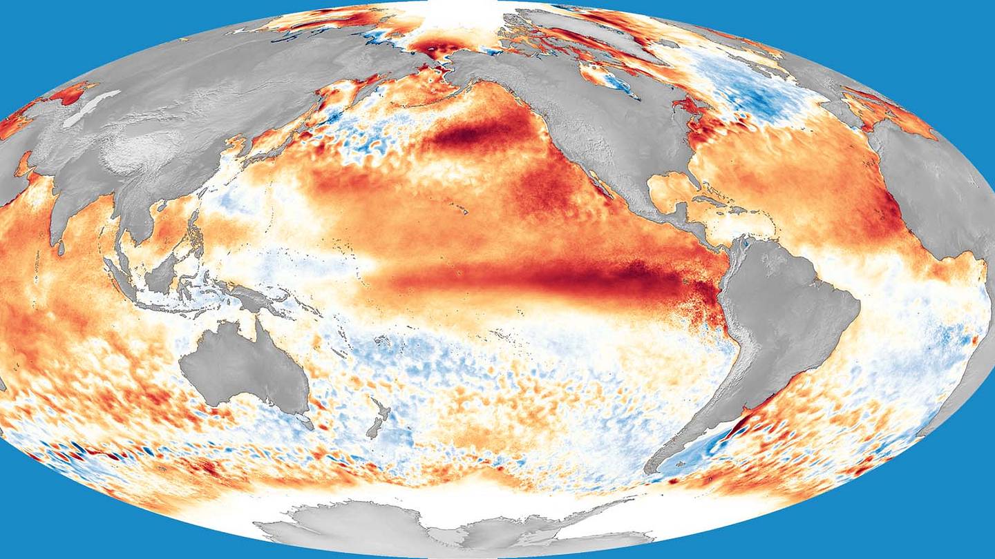
So, what is El Niño? In simple terms, El Niño is the warm phase of the El Niño-Southern Oscillation, often shortened to ENSO. ENSO is a recurring climate pattern centered in the tropical Pacific Ocean. It has three main phases: El Niño, La Niña, and neutral. El Niño happens when sea surface temperatures in the central and eastern tropical Pacific become warmer than average for several months. That ocean warmth then talks to the atmosphere, and the atmosphere, being dramatic, answers by changing wind, rain, and pressure patterns across huge parts of the planet.
El Niño matters because the tropical Pacific is not just any ocean neighborhood. It is a massive heat engine. When its temperature pattern changes, the effects ripple outward like someone dropped a bowling ball into a bathtub. The result can be wetter winters in the southern United States, warmer and drier conditions in the northern tier, floods in some regions, droughts in others, changes in marine ecosystems, and global economic consequences.
What Is El Niño?
El Niño is a natural warming of the ocean surface in the central and eastern equatorial Pacific. It usually develops irregularly every two to seven years and can last for several months or more than a year. It is not a storm, not a single heat wave, and not a hurricane. It is a large-scale ocean-atmosphere pattern that changes the odds of certain weather conditions.
The name “El Niño” means “the boy” in Spanish and originally referred to the Christ Child because fishermen off the coast of Peru noticed unusually warm ocean water around Christmas. Those warm-water episodes were not just a curiosity. They often reduced fish catches by weakening the cold, nutrient-rich upwelling that normally supports marine life along the South American coast.
El Niño vs. La Niña vs. Neutral
To understand El Niño, it helps to meet its siblings. During neutral conditions, trade winds blow from east to west across the tropical Pacific. These winds push warm surface water toward the western Pacific, while colder, nutrient-rich water rises near the coast of South America.
During La Niña, those trade winds become stronger than usual. More warm water piles up in the western Pacific, and the central and eastern Pacific become cooler than average. La Niña often produces weather patterns that are roughly opposite to El Niño, although “opposite” in climate science usually comes with a truckload of asterisks.
During El Niño, the trade winds weaken or sometimes reverse. Warm water spreads eastward across the equatorial Pacific. This changes where thunderstorms form over the ocean, alters tropical rainfall, and shifts global circulation patterns. In short, El Niño moves the atmosphere’s furniture around and forgets to ask permission.
How El Niño Forms
El Niño begins with the interaction between the ocean and atmosphere. Normally, the trade winds help maintain a temperature contrast across the tropical Pacific. The western Pacific stays warm, while the eastern Pacific remains relatively cool because cold water rises from below. This rising cold water is called upwelling, and it is extremely important for marine ecosystems.
When the trade winds weaken, warm surface water moves eastward. The central and eastern tropical Pacific warm up. As the ocean warms, thunderstorms shift eastward too. This changes air pressure patterns, rainfall zones, and the flow of winds high in the atmosphere. The entire system can reinforce itself for a while, which is why El Niño events can persist for months.
Scientists monitor El Niño using sea surface temperature data, satellite observations, ocean buoys, wind measurements, and atmospheric pressure patterns. A key region is the Niño 3.4 area of the tropical Pacific. When that region stays significantly warmer than average and the atmosphere responds in the expected way, forecasters may declare El Niño conditions.
Why Does El Niño Have Such a Big Impact?
El Niño has a big impact because it changes where the warmest ocean water sits in the tropical Pacific. Warm ocean water fuels rising air and thunderstorms. When that stormy zone shifts, it changes the circulation of the atmosphere far beyond the Pacific.
Think of the tropical Pacific as a giant climate control panel. Move the warm water, and you move the zones of rising air. Move the zones of rising air, and you alter jet streams, storm tracks, rainfall patterns, drought risks, and temperature trends. This is why a patch of warmer-than-average water thousands of miles away can affect winter weather in Texas, wildfire risk in Australia, fish populations off Peru, and rainfall in California.
The Jet Stream Connection
One of El Niño’s most important effects in the United States involves the Pacific jet stream. During many El Niño winters, the Pacific jet stream shifts south of its usual position. This can guide more storms across the southern tier of the United States, including California, the Southwest, the Gulf Coast, and the Southeast.
That does not mean every El Niño winter is a copy-and-paste weather forecast. El Niño changes probabilities, not guarantees. Other factorssuch as Arctic air outbreaks, ocean temperatures in the Atlantic, soil moisture, snow cover, and random atmospheric chaoscan modify the outcome. Weather is still weather, which means it occasionally behaves like a toddler holding a juice box.
Common El Niño Effects in the United States
In the U.S., El Niño impacts are usually strongest during the colder half of the year, especially from late fall through winter and into early spring. The most typical pattern is wetter-than-average weather across parts of the southern U.S. and warmer, drier conditions across parts of the northern U.S.
Southern United States: Wetter and Stormier
El Niño often increases storminess across the southern United States. California, Arizona, New Mexico, Texas, the Gulf Coast, and Florida can see higher odds of above-average precipitation during winter. This can help ease drought in some places, but it can also increase the risk of flooding, mudslides, severe thunderstorms, and travel disruptions.
In Florida and parts of the Southeast, El Niño winters are often wetter and can bring more frequent storm systems. That may reduce wildfire risk in some years, but it can also raise the threat of flooding and severe weather. A rainy winter can be a blessing for reservoirs and a headache for anyone who owns leaky boots.
Northern United States: Warmer and Drier
Across the northern tier of the country, El Niño often tilts winter toward warmer and drier conditions. The Pacific Northwest, northern Rockies, Upper Midwest, and parts of the Great Lakes region may experience reduced snowfall or milder temperatures compared with average winters.
This can affect ski resorts, snowpack, water supply, winter recreation, and spring runoff. Less mountain snow may sound convenient if you hate shoveling, but it can become a serious issue when farms, rivers, hydropower systems, and communities depend on snowmelt months later.
California and the West: Rain Relief or Flood Trouble
El Niño is often linked with wetter winters in California and the Southwest, especially during stronger events. However, the relationship is not automatic. Some El Niño years bring big rains; others are more modest. When storms do arrive, they can be intense, especially in areas with steep terrain, wildfire burn scars, or already saturated soils.
That is why El Niño can be both helpful and hazardous. It may refill reservoirs and reduce drought stress, but too much rain too fast can trigger flash flooding, landslides, coastal erosion, and debris flows. Nature has never been famous for portion control.
El Niño and Hurricanes
El Niño can influence hurricane activity, especially in the Atlantic and eastern Pacific. In the Atlantic basin, El Niño often increases vertical wind shear. Wind shear is a change in wind speed or direction with height, and strong wind shear can disrupt developing tropical storms. As a result, El Niño tends to suppress Atlantic hurricane activity.
In the eastern Pacific, the opposite may happen. El Niño can make conditions more favorable for tropical cyclone development by warming ocean waters and changing wind patterns. This is one reason hurricane outlooks always look at ENSO conditions along with ocean heat, atmospheric moisture, wind shear, and other climate factors.
Still, El Niño is not a hurricane off-switch. Warm Atlantic waters, local wind patterns, and other climate drivers can complicate the picture. A quieter statistical outlook does not mean coastal communities should ignore preparedness. Hurricanes do not read seasonal forecasts, and they definitely do not RSVP.
El Niño and Global Temperatures
El Niño can temporarily raise global average temperatures because the tropical Pacific releases extra heat into the atmosphere. Strong El Niño events have often coincided with very warm global years. This does not mean El Niño “causes” long-term climate change. Instead, it operates on top of the long-term warming trend driven largely by human-caused greenhouse gas emissions.
A useful way to think about it is this: climate change raises the floor, and El Niño can help push temperatures closer to the ceiling for a year or two. When a strong El Niño overlaps with an already warmer planet, heat extremes can become more intense, and weather impacts may become more costly.
El Niño’s Impact on Oceans and Fisheries
El Niño can disrupt marine food webs by reducing upwelling in key regions. Upwelling brings cold, nutrient-rich water to the surface. Those nutrients feed phytoplankton, which support small fish, larger fish, seabirds, and marine mammals. When upwelling weakens, the entire food chain can feel the squeeze.
Fish may move to cooler waters, change depth, or become less abundant in traditional fishing areas. This can affect commercial fisheries, coastal economies, and food supply. Along the U.S. West Coast, El Niño can alter ocean temperatures, currents, and biological productivity. Around South America, strong events have historically disrupted anchovy fisheries and seabird populations.
In other words, El Niño is not only a weather story. It is also an ocean story, a food story, and an economics story. The fish know. The fishermen know. And eventually, the price tags at the market may know too.
El Niño, Agriculture, and Food Prices
Farmers watch El Niño closely because crops depend on timing. Rain at the right time is helpful. Rain at the wrong time is mud with better public relations. Drought during a growing season can reduce yields, while excessive rain can delay planting, damage crops, increase disease pressure, or make harvest difficult.
In the United States, El Niño can affect regional growing conditions by changing winter precipitation, snowpack, soil moisture, and spring runoff. In the Pacific Northwest, warmer and drier El Niño winters may reduce mountain snowpack, affecting irrigation supplies later in the year. In the southern U.S., extra winter rain can improve drought conditions but may also create flooding problems.
Globally, El Niño can influence crop production in parts of Asia, Africa, Australia, and Latin America. Drought in one region and floods in another can affect grain, coffee, cocoa, sugar, rice, and livestock markets. That is one reason economists, food companies, humanitarian organizations, and governments pay attention when ENSO forecasts begin leaning toward El Niño.
El Niño and Human Health
El Niño can affect health indirectly through extreme weather. Flooding can contaminate water supplies, damage homes, and increase injury risks. Drought can worsen air quality, reduce water availability, and strain food systems. Heat waves can increase heat-related illness, especially among older adults, outdoor workers, young children, and people with chronic health conditions.
Changes in rainfall and temperature can also influence mosquitoes and other disease-carrying organisms in some regions. After floods, mold growth can aggravate asthma and allergies. After wildfires, smoke can worsen respiratory and heart conditions. Mental health can also suffer when communities face repeated disasters, property damage, displacement, or financial stress.
That is why El Niño preparation is not just about umbrellas and sandbags. It is also about public health planning, emergency communication, water safety, cooling centers, resilient infrastructure, and community support.
Is El Niño Caused by Climate Change?
El Niño is natural. It existed long before modern industrial emissions. However, climate change can influence the background conditions in which El Niño occurs. A warmer atmosphere can hold more water vapor, which can intensify heavy rainfall events. Warmer oceans can add energy to storms. Higher sea levels can worsen coastal flooding when storms arrive.
Scientists are still studying how climate change may affect the frequency, strength, and impacts of El Niño and La Niña events. The exact relationship is complex. What is clear is that El Niño impacts now unfold in a warmer world, and that can make some hazards more damaging.
How Scientists Forecast El Niño
El Niño forecasts combine ocean observations, atmospheric data, computer models, and expert analysis. Scientists monitor sea surface temperatures, subsurface heat content, trade winds, cloudiness, rainfall, and pressure differences across the Pacific.
Forecasting is easiest once the ocean-atmosphere pattern is already developing. It is harder during spring, when ENSO forecasts often face what scientists call the “spring predictability barrier.” That phrase sounds like something guarding a wizard castle, but it simply means forecasts made in spring tend to have more uncertainty.
Even when forecasters are confident El Niño will develop, local impacts remain probabilistic. A forecast can say the southern U.S. has higher odds of a wetter winter, but it cannot promise rain on your tomato plants on January 12 at 3:47 p.m. Climate outlooks are about tilted odds, not personal weather appointments.
How to Prepare for El Niño
Preparation depends on where you live. In flood-prone areas, clear gutters, inspect drainage, review insurance coverage, and prepare an emergency kit. In regions vulnerable to landslides, pay attention to local warnings, especially after heavy rain or near wildfire burn scars. In drought-prone areas, conserve water, monitor fire danger, and plan for possible restrictions.
Farmers and gardeners can watch seasonal outlooks, protect soil health, improve drainage, and plan for unusual moisture patterns. Coastal communities can prepare for erosion, high surf, and storm impacts. Families can sign up for weather alerts, make evacuation plans, and keep essential supplies on hand.
The goal is not to panic every time the Pacific gets warmer. The goal is to understand that El Niño changes risk. Good preparation turns climate information into practical decisions.
Real-Life Experiences: What El Niño Feels Like on the Ground
To understand El Niño, imagine a homeowner in Southern California after years of dry weather. The yard is dusty, the hills are brown, and everyone has become a part-time philosopher about water restrictions. Then an El Niño winter arrives. At first, the rain feels like a celebration. Roofs shine, reservoirs rise, and the smell of wet soil returns like an old friend. But after several storms, the mood changes. Gutters overflow. Hillsides loosen. Roads flood during the morning commute. That same rain that felt like rescue can become a reminder that drought relief and flood risk sometimes ride in the same car.
Now picture a ski-town business owner in the Pacific Northwest. In a typical winter, snowpack brings visitors, fills lodge rooms, and keeps rental shops humming. During some El Niño winters, temperatures run milder and snow levels rise. Rain falls where snow is expected. Ski runs open late or operate with thin coverage. Local businesses feel the difference quickly. A climate pattern thousands of miles away in the tropical Pacific suddenly shows up in payroll, hotel bookings, restaurant traffic, and weekend plans.
For a farmer, El Niño can feel like a season of complicated math. In the southern U.S., extra winter rain may recharge soil moisture and improve pasture conditions. That is good news, especially after drought. But too much rain can delay fieldwork, increase erosion, and raise disease pressure in crops. In the Northwest, a warmer winter may reduce snowpack, which can mean less irrigation water later. The same El Niño event can be helpful in one county and frustrating in another. That is why farmers do not ask, “Is El Niño good or bad?” They ask, “Good or bad for what, where, and when?”
Coastal fishermen experience El Niño differently. When ocean temperatures shift and upwelling weakens, fish may move. A captain who knows reliable fishing grounds can suddenly find them quiet. The birds are fewer. The baitfish are elsewhere. The water feels wrong. Fuel costs rise because boats travel farther to search. Seafood businesses, processors, and coastal families may all feel the impact. El Niño is not visible like a storm cloud, but for people who work on the water, it can be as real as an empty net.
Families also feel El Niño in ordinary routines. A parent in Florida may notice more rainy weekends and stronger winter storms. A commuter in Texas may deal with flooded streets. A person with asthma may struggle after damp conditions lead to mold indoors, or after drought and wildfire smoke worsen air quality elsewhere. Travelers may face flight delays as storms march across the southern states. Gardeners may lose plants to unexpected chill, soggy roots, or unusual pest patterns.
These experiences show why El Niño has such a big reputation. It is not one disaster. It is a climate pattern that nudges many systems at once: water, food, roads, health, oceans, energy, insurance, and household budgets. Sometimes the nudge is gentle. Sometimes it elbows the planet in the ribs. Understanding El Niño helps people prepare with fewer surprises, better decisions, and maybe one less emergency trip to buy batteries, bottled water, and a flashlight that should have been checked three years ago.
Conclusion
El Niño is the warm phase of ENSO, a natural climate pattern rooted in the tropical Pacific Ocean. It begins when unusually warm water spreads across the central and eastern equatorial Pacific and changes the relationship between ocean temperatures, trade winds, rainfall, and atmospheric pressure. From there, its effects can travel across the globe.
Its biggest impact comes from its scale. El Niño can shift jet streams, alter winter storm tracks, suppress Atlantic hurricane activity, disrupt fisheries, influence crop conditions, affect public health, and raise global temperatures temporarily. It does not control every storm or every season, but it changes the odds in meaningful ways.
The smartest response to El Niño is not fear. It is awareness. When communities, farmers, businesses, and families understand how El Niño works, they can prepare for floods, droughts, heat, storminess, and changing water supplies. The Pacific may be far away, but when El Niño wakes up, it has a way of knocking on doors around the world.