I went to the Peruvian Andes expecting mountains. This was a reasonable assumption. The place is, after all, famous for having quite a few of them.
What I did not expect was how quickly the landscape would make my everyday concerns feel hilariously small. An unread email? Adorable. A delayed bus? Character building. A towering wall of rock disappearing into clouds while an alpaca silently judges my hiking technique? Now we are dealing with real issues.
Traveling through the Peruvian Andes gave me ancient stone cities, steep agricultural terraces, colorful highland markets, glacial scenery, tiny villages, enormous skies, and more potatoes than I previously understood nature was capable of inventing. The trip also introduced me to the physical reality of high-altitude travel. Cusco sits around 3,400 meters above sea level, and lower oxygen levels can cause altitude illness in travelers who ascend too quickly.
I carried a camera almost everywhere. Below are 27 scenes that stuck with me, along with the stories, impressions, and occasional breathless wheezing that came with them.
The Road Into the Peruvian Andes
Pic #1: Cusco From Above
My first wide view of Cusco looked like someone had poured a city into a valley and allowed the buildings to climb the surrounding hills. Terracotta roofs spread toward dark mountain ridges, church towers interrupted the skyline, and narrow streets twisted through neighborhoods built over layers of history.
Cusco was the capital of the Inca Empire, later transformed under Spanish colonial rule. Walking there feels less like visiting a museum and more like wandering through an argument between centuries. Inca stone foundations support colonial structures, while modern taxis squeeze through streets that certainly were not designed with rush-hour traffic in mind.
Pic #2: Streets That Made Me Walk Slowly
The stone streets gave me another reason to slow down besides the altitude. Some lanes were polished by years of footsteps and became impressively slippery whenever moisture appeared.
I started watching the walls as much as the road. Large stones fitted tightly together appeared beneath later buildings. Inca engineering, road construction, drainage, and carefully fitted masonry remain some of the civilization’s most admired achievements. The broader Inca road system connected communities across an enormous stretch of the Andes.
Pic #3: A Market Full of Color
One morning, I entered a market and temporarily forgot that beige food exists. Corn appeared in unfamiliar colors. Potatoes ranged from smooth and pale to dark, knobby little specimens that looked capable of giving financial advice.
Fresh herbs, peppers, fruits, grains, and prepared foods filled the stalls. The Andes are deeply connected with crops including potatoes, corn, quinoa, and other tubers, while llamas and alpacas have long played important economic and cultural roles.
Pic #4: Textiles That Deserved a Closer Look
From across a market, Andean textiles look bright. Up close, they become complicated.
I watched the movement of hands working with fibers and patterns that carried regional character. Stripes, geometric forms, and bold combinations of color turned practical clothing and woven goods into visual records of skill. Indigenous Andean weaving traditions survived massive political and cultural changes, continuing and adapting even after the Spanish conquest.
I bought one modest woven item and immediately developed the protective instincts of a museum security guard.
The Sacred Valley Was Much More Than a Stop on the Way
Pic #5: My First Full View of the Sacred Valley
The Sacred Valley made scale difficult to process. Fields occupied the valley floor while huge slopes rose sharply on both sides. Villages appeared tiny from viewpoints, and roads became thin lines folded into the terrain.
This is where my camera started failing philosophically. The photographs were fine. The problem was that the valley seemed to have more dimensions than my camera was prepared to discuss.
Pic #6: Pisac and the Geometry of the Hills
At Pisac, terraces wrapped around the mountain in careful curves. From a distance, they looked decorative. Stand beside them, however, and their scale becomes obvious.
Terrace agriculture helped Andean societies work with steep terrain and varied growing conditions. What impressed me most was the refusal to treat a mountain as useless simply because it was inconveniently tilted.
Pic #7: Terraces Dropping Toward the Valley
This image became one of my favorite Peruvian Andes photos because it showed both human planning and wild geography in a single frame.
The terraces descended in repeated steps, while beyond them the valley opened toward distant peaks. There was no clean border between archaeology and landscape. The two belonged together.
Pic #8: Ollantaytambo, Where History Has Traffic
Ollantaytambo was wonderfully confusing. Ancient stonework, narrow lanes, flowing water channels, restaurants, homes, travelers, and trains all shared the same compact town.
It did not feel like an archaeological display that had been separated from modern life. People live among structures and street patterns connected to the Inca past. I spent far longer than planned walking without a destination, which is one of my more successful travel strategies.
Pic #9: Water Still Running Through Old Channels
I crouched beside a water channel and listened to the current moving through the town. The sound was surprisingly calming until I remembered I was blocking a walkway and had become an obstacle to several residents.
The Andean environment makes water management essential. Inca engineering incorporated channels and drainage into settlements, and even Machu Picchu’s survival is closely associated with careful planning around rainfall and water movement. Smithsonian reporting has also highlighted research into how local geology and natural fractures may have influenced the placement and drainage of major Inca sites.
Pic #10: Alpacas With Excellent Hair
I photographed alpacas. Of course I did.
They stood against the mountains looking as though they had personally approved the scenery. One turned toward my camera with a hairstyle that would require a salon appointment and several expensive products back home.
Humor aside, alpacas are bred for fiber, and their fine fleece has long supported weaving traditions and local economies in the Andes.
Pic #11: Potatoes, Potatoes, and Additional Potatoes
Before traveling through the Peruvian highlands, I thought I understood potatoes. I did not.
Highland markets and meals introduced me to an astonishing variety of shapes, textures, and colors. Potatoes and other native Andean crops are not merely tourist curiosities; they are connected with agricultural knowledge, local diets, and generations of adaptation to difficult environments.
My scientific conclusion was equally important: I remain willing to eat almost any potato placed near me.
Pic #12: Moray Looked Like an Ancient Amphitheater
The circular terraces of Moray produced one of the strangest views of my journey. Concentric levels sank into the ground, creating a design so mathematically satisfying that my camera roll suddenly contained 18 nearly identical photographs.
The site is frequently associated with Inca agricultural experimentation and the use of varied growing conditions. Whatever details scholars continue to investigate, standing at the edge makes one point extremely clear: Andean agriculture demanded close observation of elevation, soil, temperature, and water.
Pic #13: Salt Ponds on a Mountainside
At Maras, hundreds of small salt ponds formed a pale patchwork across a steep slope. Water moved through narrow channels and fed the shallow pools.
From above, the ponds resembled tiles. At ground level, they became a working landscape shaped by repeated human effort. This was another recurring theme of my trip: many of the Andes’ most photogenic places are not simply scenery. They are places where people have worked.
Higher Into the Mountains
Pic #14: Four Seasons Before Lunch
Highland weather developed a personal grudge against my clothing choices.
The morning began cold. Then sunlight arrived and I removed a layer. Wind appeared, so the layer returned. Clouds arrived. The temperature dropped. Ten minutes later, the sun was back and apparently operating on maximum power.
At altitude, travelers also face stronger ultraviolet exposure, lower humidity, cold, and reduced air pressure. The CDC recommends giving the body time to acclimatize and avoiding heavy exercise during the first days after a rapid ascent to high elevation.
Pic #15: Mountains That Really Were That Colorful
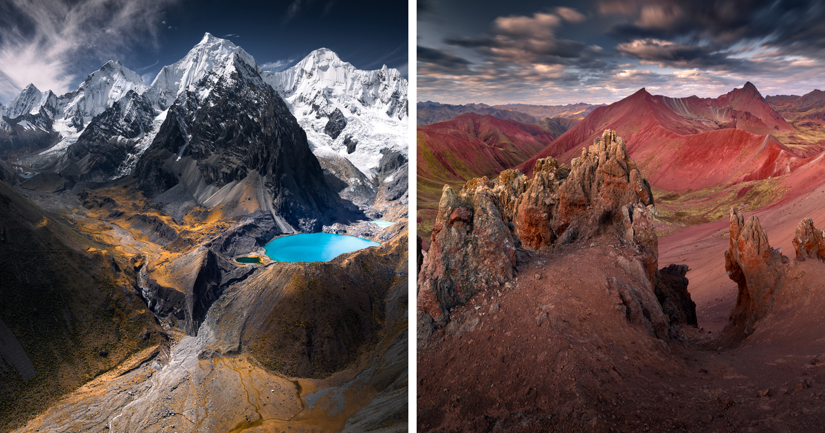
Mineral-rich slopes in the Peruvian Andes can display bands and patches of red, brown, yellow, greenish, and gray rock. In famous high-elevation landscapes near the Vilcanota range, erosion exposes colorful layers beside glaciers and glacial lakes.
NASA imagery and observations of Peru’s tropical Andes show exactly how extraordinary this combination of weathered rock, high peaks, ice, and vivid lakes can be.
I took a photograph. Then another. Then I moved six feet and took the same photograph again because apparently that was my artistic process.
Pic #16: Llamas Crossing My Route
A group of llamas moved across the landscape with zero interest in my itinerary.
This was reasonable. Llamas have been part of Andean transportation and highland life for centuries. My backpack and I, by contrast, had arrived recently and were already complaining.
Pic #17: A Glacial Lake Like Blue Glass
Some high Andean lakes looked almost digitally edited. Their intense color stood against pale rock, grass, and snowy ridges.
The beauty comes with a sobering context. Peru contains a major concentration of tropical glaciers, and retreating ice is changing mountain landscapes and water systems. Seeing ice in the distance made climate change feel less like a graph and more like a visible process.
Pic #18: Sunrise in the High Country
Sunrise gave the mountains a temporary softness. Peaks that looked severe during the afternoon turned gold around the edges.
I stood outside wearing nearly every layer I owned and watched light move across the ridges. The entire performance was free, though the price of admission apparently included waking up at an hour normally reserved for bakers and questionable airport departures.
Following Traces of the Inca World
Pic #19: A Stone Trail Disappearing Around the Mountain
On sections of old Andean paths, I kept thinking about movement. Messages, food, textiles, armies, administrators, and communities once traveled through a vast road system engineered across extraordinarily difficult terrain.
The mountain had not become easier. Modern travelers simply have better socks.
Pic #20: Machu Picchu Appearing Through Mist
There are famous places that feel smaller after years of seeing photographs. Machu Picchu did the opposite.
Mist shifted across the ridge, revealing terraces and stone structures in pieces. The UNESCO World Heritage site stands about 2,430 meters above sea level where the Peruvian Andes meet the upper Amazon Basin. Its architecture and land use are inseparable from the dramatic surrounding landscape.
I had seen the classic view countless times. Standing there still felt completely different.
Pic #21: Stonework That Made Me Question My DIY Skills
I moved closer to the walls and stared at fitted stones. Certain examples of Inca masonry sit together with remarkable precision.
Then I remembered a shelf I once installed at home. It leaned visibly to the left.
The contrast was emotionally difficult.
Pic #22: Terraces Above the Urubamba
The terrain around Machu Picchu is steep enough to make the site seem improbable. Terraces descend along the slopes, while mountains crowd the horizon and the Urubamba River curves through the valley below.
This was one of the moments when I stopped photographing. Sometimes the urge to document a place gets in the way of actually looking at it.
Beyond the Famous Postcard Views
Pic #23: A Condor Above the Canyon
In the southern Peruvian Andes, Colca Canyon is known for dramatic walls, agricultural terraces, and opportunities to see Andean condors. National Geographic has described the canyon’s enormous vertical scale and the regular appearance of condors around Cruz del Condor.
Watching a large bird use rising air to move with barely visible effort is inspiring. Watching it while you are exhausted from walking uphill is also slightly insulting.
Pic #24: A Village Soccer Game
One of my most memorable photographs was not of a ruin or mountain. It was a soccer game on a rough field surrounded by highland scenery.
The game continued as clouds moved over the peaks. Children chased the ball, adults watched from the side, and for a while I put the camera down.
The Andes are home, not a backdrop. That distinction became more important to me with every village I passed through.
Pic #25: Lake Titicaca Under a Giant Sky
Near Lake Titicaca, sky and water competed for most of the photograph. At high elevation, the light felt sharp and the horizon seemed unusually clean.
The Lake Titicaca region is deeply connected with Aymara and Quechua cultures and with a much longer history of Andean societies that predates the Inca Empire.
I sat near the water for longer than planned. This happened frequently in Peru. My schedule was very ambitious until scenery became involved.
Pic #26: More Stars Than My Camera Could Handle
At night, away from strong city lights, the highland sky was astonishing.
My camera produced a photograph that looked respectable. My eyes saw something far better. The Milky Way stretched above dark mountain outlines, and the cold eventually convinced me to return indoors.
Nature: 1. My thermal tolerance: 0.
Pic #27: The Road Out
My final photograph from the Peruvian Andes showed a road curving through brown grassland toward distant mountains.
There was no famous monument in the frame. No llama had volunteered for foreground duty. It was simply a long road, enormous land, and fading afternoon light.
That image became the one I returned to most often.
The Experiences That Stayed With Me After the 27 Photos
Altitude Changed the Way I Moved
The first lesson the Andes taught me was physical: my normal walking speed was a suggestion, not a legal requirement.
At lower elevations, I tend to travel quickly. I want to reach the next viewpoint, cross the next street, order the next coffee, and somehow win tourism by 4 p.m. In Cusco and the higher Andes, my body rejected this strategy.
I learned to walk more slowly. I rested when I needed to. I paid closer attention to how I felt instead of treating discomfort as an enemy that could be defeated through stubbornness. Travelers heading to high elevations should take altitude seriously, plan time for acclimatization, and seek medical advice when appropriate rather than assuming enthusiasm provides extra oxygen.
The funny thing was that moving slowly improved the trip. I noticed carved stones, courtyard doors, dogs sleeping in sun patches, water channels beside streets, and conversations happening around market stalls. A slower body created a more observant traveler.
I Stopped Treating Machu Picchu as the Entire Story
Before my trip, the route through the Peruvian Andes had one giant star on the map: Machu Picchu.
I still think the site deserves its reputation. Seeing the citadel appear through mist was one of the great travel moments of my life. But the Sacred Valley, Cusco, Moray, Maras, Pisac, Ollantaytambo, and the smaller communities along the road changed how I understood the region.
Condé Nast Traveler has similarly highlighted the value of slow travel in the Sacred Valley and looking beyond a single bucket-list attraction.
The memorable moments often happened between scheduled destinations. A driver pointing toward a distant village. A market lunch I ordered with incomplete Spanish. An alpaca blocking a path. A sudden storm changing every color in the valley.
None of these moments had entrance tickets.
Photography Made Me Look, but Sometimes I Had to Stop Shooting
Travel photography creates a strange conflict. You visit somewhere because you want to experience it, then immediately place a small electronic rectangle between your face and the experience.
I love taking pictures. The camera helps me notice lines, textures, faces, light, and small changes in weather. In the Peruvian Andes, every turn seemed designed for a wide-angle lens.
Yet some of my strongest memories come from the occasions when I deliberately lowered the camera.
I remember the sound of water in Ollantaytambo more clearly than the exact photograph I took there. I remember sunlight warming one side of my face at Machu Picchu. I remember cold air before sunrise, the smell of food in a market, and the silence beside a high-altitude lake.
A photograph can bring a moment back. It cannot always explain why the moment mattered.
The People and the Landscape Cannot Be Separated
One mistake travelers can make in the Andes is treating the mountains as an empty wilderness decorated occasionally with photogenic locals.
That is not what I saw.
I saw working agricultural landscapes, inhabited towns, marketplaces, roads, schools, herds, religious traditions, tourism businesses, and communities managing the realities of modern life. Quechua and Aymara cultures are not chapters that ended when the Inca Empire fell. Indigenous traditions, languages, farming practices, textile knowledge, and cultural identities remain part of the contemporary Andes.
This changed the way I photographed people. I became more careful about permission and context. A colorful piece of clothing does not turn a person into public scenery. A market is a workplace before it is my travel photograph.
Respect is not complicated. Ask when possible. Accept no. Learn a few polite words. Buy directly from artisans when appropriate. Follow archaeological site rules. Do not climb on protected structures for a dramatic social media pose. The mountain already looks impressive. It does not need anyone doing yoga on a wall.
I Came Home With a Different Definition of a Big Place
The Peruvian Andes made the world feel physically enormous again.
Modern life is excellent at shrinking distance. Maps load instantly. Flights cross continents overnight. Photographs of Machu Picchu can appear on a phone while someone waits for a sandwich in Ohio.
Then you stand in a valley where mountains rise thousands of feet above you. You watch clouds take an hour to cross a ridge. You follow a road that disappears through terrain once connected by an immense Andean network of trails.
Suddenly, distance means something again.
I returned home with 27 favorite photographs and hundreds of less disciplined ones. I also came back with dusty shoes, an increased respect for potatoes, and the certainty that the Peruvian Andes cannot be reduced to one ancient city or one perfect Instagram frame.
Conclusion: The Peruvian Andes Are Bigger Than the Pictures
Looking through these Peruvian Andes photos, I can remember where I stood and what I tried to fit inside each frame. The Sacred Valley stretched beyond my lens. Cusco layered one era over another. Glacial landscapes revealed both extraordinary beauty and environmental change. Ancient roads and terraces showed how generations of Andean people adapted to difficult terrain.
And yes, Machu Picchu was magnificent.
But my favorite memories also include quiet roads, local markets, water running beside old stone streets, a village soccer game, and llamas behaving as though international tourism were a minor administrative inconvenience.
The 27 pictures brought pieces of the journey home. What they cannot fully show is the altitude, the cold, the silence, the distances, or the feeling of turning a corner and discovering another mountain filling the sky.
For that, apparently, I will have to go back.
Note: The 27 numbered scenes are structured as editorial captions for a photo-led travel feature and should be paired with original or properly licensed images that match each described location and experience.